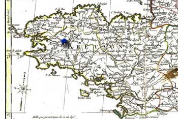
Bretagne.

The province is formed by a triangle of land which juts out into l'océan Atlantique like a finger pointing west. Once part of the 1st century Roman province of Briton, its history dates back hundreds of thousands of years as evidenced by the 450,000 year old hearth in the coastal town of Plouhinec.
Frances I declared the Bretons did not have to pay the 1532 gabelle, or salt tax. It was governed as a country separate from France, though they shared a king. Trade flourished with England, the Netherlands, and Spain. And in times of war the walled city of Saint-Malo on the Manche was home to corsairs, state sanctioned pirates who raided ships belonging to nations opposing France.
Craftsmen made the town of Fougères famous since the middle ages. The Italians brought their glass making skills to the town's tin smiths, tanners, weavers and drapers.
Nantes came to be known as the Venice of the West due to its proximity to the Loire, Erdre and Sèvre Rivers. Later, in the 1700's Nantes became an active port in the slave trade from Africa. As in much of France, wine is important. A hardy grape varietal was planted after a hard freeze in 1709 killed many vines. The white Muscadet grape grew well in the fertile lands near Nantes and came to be favored when paired with seafood such as oysters.
By departing in the mid 1600's our ancestors missed the economic decline that beset the region. New taxes, including those on paper and tin were particularly vexing to the peasantry.
Our ancestors who emigrated from Bretagne, or Brittany, are listed below. The dates reflect the year they arrived in Canada if known, otherwise it is the date of their earliest appearances in the records there:
- Hughes Picard (1653) of Nantes.
- Jean Ronceray (1665) of Fougères.
- Pierre Forcier (1669) of Nantes.
- Image: Detail of Normandie, Bretagne, Maine, ANjou, Touraine et Saumurois. Par le S. Robert de Vaugondy, author's collection
